- Joined
- Jul 22, 2020
- Messages
- 38
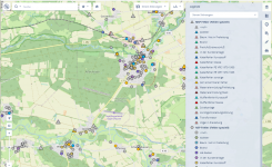
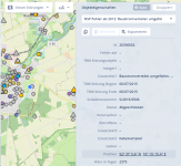
Cool map by FPL showing System Improvements (areas being worked) and Power Tracker (showing outages). I wonder if they are using their Smallworld data for this?

 energycentral.com
Would be cool to stand up something like this with GSA and GSA Lite maybe?
Has anyone else done something like this?

Florida Power and Light Customers Can Quickly and Easily See Neighborhood Energy Grid Improvements With an Updated Interactive Map
JUNO BEACH, Florida, Feb. 10 -- Florida Power and Light, a subsidiary of NextEra Energy, issued the following news release:For more than 15 years, Florida Power & Light Company has been enhancing the energy grid, making it stronger, smarter and more storm-resilient to keep the lights on for...
Would be cool to stand up something like this with GSA and GSA Lite maybe?
Has anyone else done something like this?


