- Joined
- Sep 28, 2019
- Messages
- 38
Hi!
As a user of Lite (or derived applications) you are probably using one of the serviceproviders that have been delivered as a sample (Bing, Openstreetmap, Google etc). Ever questioned if you could also use the services of an ArcGIS server for that? Yes you can!
If your organisation -or a partner- has an ArcGIS server, you might be familiar with the REST services interface. This page gives you insight in the available services.
For Lite, you will need a Mapserver map with a WMTS capability. The default url for the REST services interface is https://(ArcGIS server host)/arcgis/REST/services
You'll find something like this: nationalmap REST services
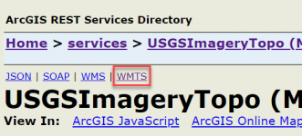
If you select a service, make sure it has the WMTS capability published.
Many services don't have that. If it is not available in the service you'd like to use, you should ask the ArcGIS server administrator to (re)publish the service with this capability. An additional requirement is that the WMTS capability has the tile scheme GoogleMapsCompatible applied. You can either read this from the WMTS capabilities XML (follow the WMTS link at the upper part of the page) and find if it has the tag
Once the Mapservice WMTS capability has a Google Maps/Bing Maps/ArcGIS Online compatible tiling scheme, make sure to populate your WMTS map cache.

Hook up GSA Server using the serviceproviders.xml ( Service Providers - X&Y Server User Guide (spatial-eye.com) ) and derive your local ArcGIS configuration from the sample below (working sample using the wayback maps):
As a user of Lite (or derived applications) you are probably using one of the serviceproviders that have been delivered as a sample (Bing, Openstreetmap, Google etc). Ever questioned if you could also use the services of an ArcGIS server for that? Yes you can!
If your organisation -or a partner- has an ArcGIS server, you might be familiar with the REST services interface. This page gives you insight in the available services.
For Lite, you will need a Mapserver map with a WMTS capability. The default url for the REST services interface is https://(ArcGIS server host)/arcgis/REST/services
You'll find something like this: nationalmap REST services
If you select a service, make sure it has the WMTS capability published.
Many services don't have that. If it is not available in the service you'd like to use, you should ask the ArcGIS server administrator to (re)publish the service with this capability. An additional requirement is that the WMTS capability has the tile scheme GoogleMapsCompatible applied. You can either read this from the WMTS capabilities XML (follow the WMTS link at the upper part of the page) and find if it has the tag
<WellKnownScaleSet>urn:ogc:def:wkss:OGC:1.0:GoogleMapsCompatible</WellKnownScaleSet>, or follow the publish instructions on https://enterprise.arcgis.com/en/server/latest/publish-services/windows/wmts-services.htm and https://enterprise.arcgis.com/en/se...ws/tutorial-creating-a-cached-map-service.htm (>> Setting up ArcMap to use the same scales as ArcGIS Online, Bing Maps, and Google Maps).Once the Mapservice WMTS capability has a Google Maps/Bing Maps/ArcGIS Online compatible tiling scheme, make sure to populate your WMTS map cache.

Hook up GSA Server using the serviceproviders.xml ( Service Providers - X&Y Server User Guide (spatial-eye.com) ) and derive your local ArcGIS configuration from the sample below (working sample using the wayback maps):
Code:
<TileServiceProvider Name="Wayback WMTS"
                       Description="Wayback WMTS">
    <Images Url="ESRI" >
        <Image Size="16">WorldImagery24.jpg</Image>
        <Image Size="24">WorldImagery24.jpg</Image>
    </Images>
    <Styles>
        <Style Name="Sample WMTS"
                 Description="Sample WMTS"
                 MinLevel="1"
                 MaxLevel="18"
                 Attribution="© Esri">
            <Images Url="ESRI" >
                <Image Size="16">WorldImagery24.jpg</Image>
                <Image Size="24">WorldImagery24.jpg</Image>
                <Image Size="32">WorldImagery32.jpg</Image>
                <Image Size="64">WorldImagery64.jpg</Image>
            </Images>
            <Urls>
                <Url>https://wayback.maptiles.arcgis.com/arcgis/rest/services/World_Imagery/WMTS/1.0.0/GoogleMapsCompatible/MapServer/tile/5359/[level]/[y]/[x]</Url>
            </Urls>
        </Style>
    </Styles>
</TileServiceProvider>