- Joined
- Oct 20, 2023
- Messages
- 2
Just discovered the resource and hoping to find some help with a new venture we are undertaking, exporting from our Smallword 5.1.8 to an SQL instance, using GSA Ultimate 5.2.11
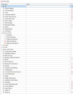
In our GIS we are using mapped geometries, 'centreline' mapped on "Operating Voltage" in this example, obviously the user only ever see's the single 'centreline' geometry.
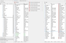
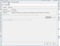
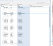
When I add the table into GSA, it is showing the single geometry in the Business Collection Designer (good!), but when I goto the Warehouse Target Model Mapping section, the geometry has been split out. This, then transfers to the SQL instance and is adding great confusion to the end user.
Is there a simple way to prevent this? or should I be instead creating a generic centreline and using an expression to merge them all back to a single geom feature?
I've attached a sample of our setup, which I hope helps!
In our GIS we are using mapped geometries, 'centreline' mapped on "Operating Voltage" in this example, obviously the user only ever see's the single 'centreline' geometry.
When I add the table into GSA, it is showing the single geometry in the Business Collection Designer (good!), but when I goto the Warehouse Target Model Mapping section, the geometry has been split out. This, then transfers to the SQL instance and is adding great confusion to the end user.
Is there a simple way to prevent this? or should I be instead creating a generic centreline and using an expression to merge them all back to a single geom feature?
I've attached a sample of our setup, which I hope helps!